There’s been another step-change in AI capabilities over the past month (for my Deseret News article on what this means for mathematicians, see here, I’ll just note that BYU professors are a lot more cheerful about things than the usual characters we hear from on this issue–maybe it’s our optimistic Mormon temperament).
If I had money and time I could, for example, vibe code a first-person shooter that would have normally cost thousands of people-hours and hundreds of thousands if not millions of dollars. I have neither the money nor the time, but one thing it can now do with my $20-a-month tier is create bespoke KMZ/KML geospatial Google Earth files. This was sort of a retirement project for me, but I can automate the process now.
- Joseph Smith’s Independence Temple Complex Imposed on Modern-Day Independence.
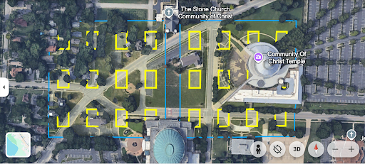
I had a seminary teacher who very much held to the “we’re going back to Independence and building it up according to Joseph Smith’s specifications” school of thought. To be clear, I don’t hold to that particular paradigm anymore (although I’m not necessarily dismissing it either), but still, I was intrigued when he described it as a sort of temple complex, of course envisioning dozens of Bountiful-sized temples, so I received an education when the Astra Codex pulled the Independence City plans from the Joseph Smith Papers Project and imposed the footprints of the temple complex on the modern-day Google Earth snapshot of the Independence temple lot area.
Others more knowledgeable than I can perhaps correct me, but it looks like it’s about 20 meters off since I thought the “Temple Lot” church was supposed to be over the foundations for the central temple? Still, the relatively small temple footprints appear to check out, since I checked the original source and they were indeed meant to be 97 x 61 feet each. Maybe it would have made more sense to just make one bigger temple, but given early 19th-century American frontier building technology that was probably about as close as they could get to building the mother of all community centers/downtowns (again, given that early temples were hybrid meeting houses/ordinance centers).
See KML/KMZ files here (just navigate to Google Earth and file-> load to play around with it).
- Traditional Tribes of Israel Boundaries Imposed on Modern-Day Israel Borders.
In the same spirit as “we’re all going to return to Independence,” there’s the “the 12 tribes will eventually return to their same homelands” school of thought, and as a pre-teen I would look at those 12 tribes of Israel maps in the quad and wondered about what the original Ephraimite homeland would look like.*
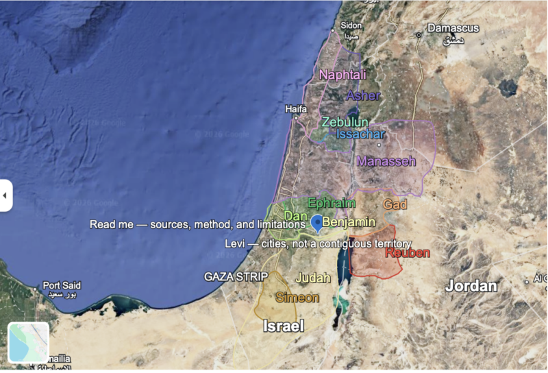
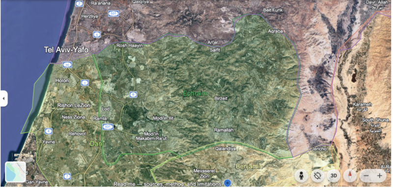
(Incidentally, until I did this exercise I didn’t realize that Jerusalem was actually not in Judah territory, but Benjamin’s).
So we would probably need inner-SLC-level density to fit all the Utah Mormon Ephraimites into the blotch of the West Bank/Israel that was the traditional Ephraimite homeland according to the Book of Joshua.
- Ultimate Jesus Jerusalem Guide
My biggest still unaccomplished “bucket list” item is to visit Israel, and in particular Jerusalem. I’ve spent hours reading books and Wikipedia articles about the Temple Mount, Church of the Holy Sepulchre, Crusader Kingdom, and on and on. Things have just never come together for it to come to pass. (At one point I had scraped together enough time and money to go, and then COVID hit).
The problem is that there is so much to hit even once you’ve done the big ones. Speaking of Ephraim, I’d want to visit Shiloh and Shechem, the Jerusalems before Jerusalem, I want to visit the actual Mt. Zion in Jerusalem next to the Temple Mount, hike the Israel National Trail, kayak in the Sea of Galilee during a storm, ford the Jordan River, hike the Samaritan temple mount at Mt. Gerizim, and (at the risk of cultural appropriation) pray at Rachel’s tomb for the infertile in my family and friend circles.
I thought that noting and mapping all the sites (and yes, I know that the vast majority of biblical sites are more tradition than historically verified reality, although some are the latter) would take me days, but I had Astra create a point-by-point guide with blow-up information about historical reliability and the scriptures discussing the location for Jerusalem and the surrounding areas like Bethlehem.
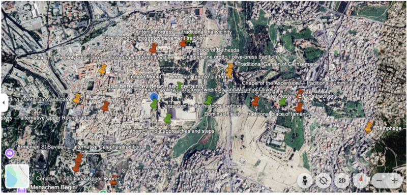
(One of my main insights from this exercise was realizing just how many competing sites there are. It seems like every traditional biblical site has a Catholic location, Orthodox location, and sometimes Protestant location.)
I also made another one for Jesus sites outside of the Jerusalem area, and one for Old Testament sites. Finally, because why not, I created one showing speculated locations for the Garden of Eden, as well as one about speculated locations for Book of Mormon events (to admit my own lack of education, before I assumed that the Sorenson model placed the “narrow neck of land” in Panama, I didn’t realize it’s actually farther north in the isthmus; shows how up-to-date I am on Book of Mormon geography).
______________________________________________________
*Yes yes, all you buzzkills, I know that that’s not the way that historical demography works, that if there are any descendants of Ephraim around today we’re all descendants of Ephraim, that 12-tribe-specific groupings were probably not biologically retained across 3 millennia and that tribal membership is more spiritual, etc., etc.
Leave a Reply